
Patas bntasan:Satellite image of Philippines in March 2002.jpg

Muda qmita prparu ni blbila: 460 × 600 patas hnigan. Duma msleexan qtaan: 184 × 240 patas hnigan | 368 × 480 patas hnigan | 589 × 768 patas hnigan | 785 × 1,024 patas hnigan | 1,570 × 2,048 patas hnigan | 4,600 × 6,000 patas hnigan.
Ida nkiya pusu patas (4,600 × 6,000 patas hnigan, pusu patas prparu ni blbila: 3.58 MB, MIME mdka hnigan: image/jpeg)
Ramas kari
| Pgkla rmngaw |
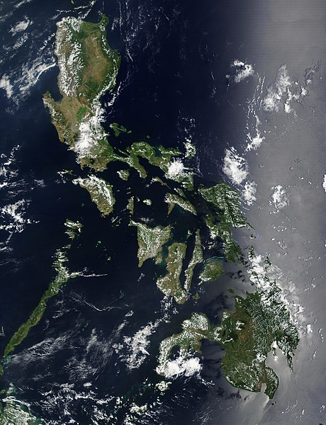
Satellite image of Philippines in March 2002. |
| Jiyax | |
| Pnyahan | http://visibleearth.nasa.gov/view_rec.php?id=2689 |
| Seejiq pnatas | NASA |
Gaya mgay biyax kklawa
| 本作品由NASA創作,屬於公有領域。根據NASA的版權政策:“NASA的創作除非另有聲明否則不受版權保護。”(參見:Template:PD-USGov/zh,NASA版權政策或JPL圖像使用政策) | ||
 |
警告:
|
Endaan pusu patas
Gmaaw jiyax/saw jiyax pqita jiyax siida ka pusu patas.
| Jiyax/Jiyax | Patas snblaqan | Sspngan knbragan | Seejiq mduuy | Patas numal pgkla | |
|---|---|---|---|---|---|
| sayang | 2004年12月21日 (J2) 19:32 | | 4,600 × 6,000(3.58 MB) | Hautala | {{PD-USGov-NASA}} Satellite image of Philippines in March 2002. Taken from NASA's Visible Earth http://visibleearth.nasa.gov/cgi-bin/viewrecord?12847 . Description: Red dots (or outlines in the high-resolution imagery) indicate MODIS9 detection of thermal |
Djiyun pusu patas
bnkgan truma ruwahan pusu dmuuypusu patas
Qtaan ddui kana patas pusu
Truma nii ka duma Wiki dmuuy ka kingal pusu patas:
- af.wikipedia.org ka qtaan dmuuy
- bg.wikipedia.org ka qtaan dmuuy
- bn.wikipedia.org ka qtaan dmuuy
- ca.wikipedia.org ka qtaan dmuuy
- da.wikipedia.org ka qtaan dmuuy
- de.wikipedia.org ka qtaan dmuuy
- de.wikinews.org ka qtaan dmuuy
- en.wikipedia.org ka qtaan dmuuy
- Outline of the Philippines
- Deforestation by continent
- Deforestation in the Philippines
- Wikipedia:Featured picture candidates/Satellite image of the Philippines
- Wikipedia:Featured picture candidates/September-2012
- Wikipedia:Featured picture candidates/February-2014
- Wikipedia:Featured picture candidates/Philippines (Satellite)
- en.wikiversity.org ka qtaan dmuuy
- en.wiktionary.org ka qtaan dmuuy
- fi.wikipedia.org ka qtaan dmuuy
- gl.wikipedia.org ka qtaan dmuuy
- he.wikipedia.org ka qtaan dmuuy
- תבנית:הידעת? 5 בנובמבר - סדרה 2
- פורטל:ארצות הברית/הידעת?/קטעי הידעת
- פורטל:ארצות הברית/הידעת?/50
- פורטל:יפן/הידעת?/קטעי הידעת
- תבנית:הידעת? 5 בנובמבר 2014
- ויקיפדיה:הידעת?/2014/נובמבר
- ויקיפדיה:הידעת?/2016/נובמבר
- תבנית:הידעת? 5 בנובמבר 2016
- ויקיפדיה:הידעת?/2018/נובמבר
- תבנית:הידעת? 18 בנובמבר 2018
- תבנית:הידעת? 1 בנובמבר 2019
- ויקיפדיה:הידעת?/2019/נובמבר
- ויקיפדיה:הידעת?/2021/נובמבר
- תבנית:הידעת? 7 בנובמבר 2021
- פורטל:יפן/הידעת?/23
- תבנית:הידעת? 5 בנובמבר 2023
- ויקיפדיה:הידעת?/2023/נובמבר
- ht.wikipedia.org ka qtaan dmuuy
- incubator.wikimedia.org ka qtaan dmuuy
- mdf.wikipedia.org ka qtaan dmuuy
- nl.wikipedia.org ka qtaan dmuuy
- nl.wiktionary.org ka qtaan dmuuy
- no.wikipedia.org ka qtaan dmuuy
- pap.wikipedia.org ka qtaan dmuuy
- pl.wikinews.org ka qtaan dmuuy
- qu.wikipedia.org ka qtaan dmuuy
- sk.wikipedia.org ka qtaan dmuuy
- sm.wikipedia.org ka qtaan dmuuy
- sr.wikinews.org ka qtaan dmuuy
Pqita pusu patas nii ka knlala qtaan kana saw kiya dmuuy.